The central area of the game screen between the Upper bar and the Lower bar, contains the map of the game :
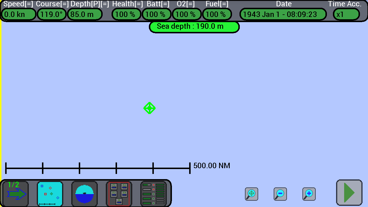
At the center there is the symbol of your submarine.
Size of the map :
The game takes place inside a large square area of sea with the side long 1000 miles (1000 NM) and to see it all, you can move the map on the screen and enlarge it.
To move the map it is sufficient to put and then move one finger across the screen, to zoom in or out just place two fingers together on the screen and then move them away or bring them closer (as in Google Maps, “pinch to zoom”).
To zoom in or out, you can also use the 2 buttons ![]() and
and ![]() , at the bottom of the screen.
, at the bottom of the screen.
The border of the map is marked with a yellow outline that you can see on the edge of the screen when you moves it all in one direction, and the map will change color depending on the time of day (Blue during day, dark blue during sunrise and sunset, gray at night).
You can not rotate the map, the North is always at the top, the South at the bottom, East on the right and West on the left.
The map can be shown with or without terrain, press on the map button ![]() in the lower bar to change the visualization mode :
in the lower bar to change the visualization mode :
1) Map without terrain, use this mode to not be confused by too many colors:
2) Map with terrain, use this mode if you like it, but the refresh can be a bit slow :
Visible and invisible units :
Your submarine is always visible in the map, while the other units are visible only if they have been detected.
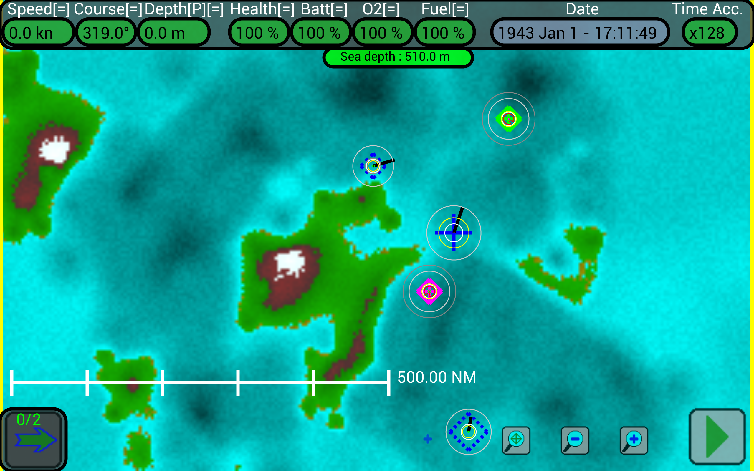
The other units are first invisible, then appear in gray when they are detected and change color when they hare identified (blue = allied, red = enemy, black = neutral).
When a unit is out of your sensors ranges, after 4 hours it disappears from the map.
Note: when units identify other units, they report it continuously via radio, if you are at surface at least 500 miles (500 NM) from an allied ship you are able to pick up the signal and these other units will appear on the map !!
Use this button ![]() in the lower bar to select and center your submarine in the map.
in the lower bar to select and center your submarine in the map.
Map scale :
To get an idea of distances, especially when you zoom in or out the map, at the bottom of the screen there is a scale drawn with a horizontal line and small vertical segments.
In the figure below you can see the yellow border of the map and the line of the scale long 500 miles (500 NM), with 5 segments each of 100 miles (100 NM) :
In the figure below instead the line of the scale is long 0.08 miles (0.08 NM), with 8 segments each 0.01 miles (0.01 NM) :
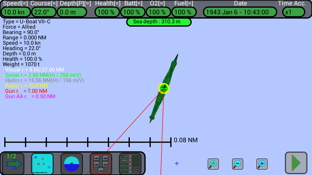
In the middle you see the drawing of the submarine with very enlargement.
Representation of the units :
The various units are indicated on the map in a different way (see Units for full details), depending on if they are allies or enemies, the type of unit, the size of the unit, the zoom of the map and so on :
Normally they are marked with a symbol (diamond, square, etc..), but when they are identified and when the map is zoomed the alley and enemy units are indicated with a more detailed drawing.
If a unit is out of your sensors’ range it is indicated with a dashed symbol, its position is calculated based on the last detection and is maintained on the map for 4 hours.
The symbols are :
![]() Your submarine
Your submarine
![]() Torpedoes Transport
Torpedoes Transport
![]() Warship
Warship
![]() Merchant or passenger ship
Merchant or passenger ship
![]() Airplane
Airplane
![]() Torpedo
Torpedo
![]() Depth Charge
Depth Charge
The size of the symbol is great for large units, small for small units :
![]()
![]()
![]()
![]()
![]()
![]()
The colors of the symbols are :
![]() Your submarine
Your submarine
![]() Torpedoes Transport (Allied)
Torpedoes Transport (Allied)
![]() ALLIED
ALLIED
![]() ENEMY
ENEMY
![]() NEUTRAL
NEUTRAL
![]() Not identified
Not identified
When the units are detected and then identified, and the map has a great magnification, the color of the drawings is as follows :
![]() Your submarine
Your submarine
![]() Torpedoes Transport
Torpedoes Transport
![]() ALLIED
ALLIED
![]() ENEMY
ENEMY
![]() NEUTRAL
NEUTRAL
When the units are in motion, together with the symbol appears a black line of length proportional to the speed and oriented toward the direction in which the unit navigates.
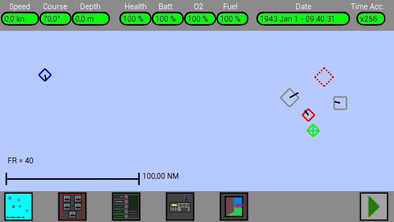
In the figure below you can see your own submarine (green) stopped at surface with a course of 70°, a large enemy warship stopped and out of range (red and dashed), a small allied warship that moves toward south (blue), a large not identified warship (gray) that moves toward north-est, a big trade ship not identified that moves toward west (gray) and a small enemy warship that moves toward nord-west (red) :
Units selection :
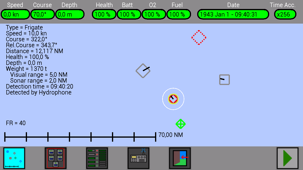
It is possible to select your submarine or other units by touching them on the map, when a unit is selected the info panel appears on the left side of the screen with useful information for that unit (see the table below):
| Type | (warship, merchant, …) |
| Team | (allied, enemy, …) |
| Bearing | its bearing |
| Range | its distance |
| Speed | its speed |
| Heading | its course |
| Depth | its depth |
| Health | its health |
| Weight | its weight |
| Visual range (white) | range of its sight |
| Sonar range (gray) | range of its sonar |
| Hydro range (black) | range of its hydrophones |
| Radar range (yellow) | range of its radar |
| Gun range (red) | range of its gun |
| Gun AA range (purple) | range of its AA gun |
| Detection time | last detection time |
| Detection type | (by sonar, by radar, …) |
To deselect a unit, tap it again.
When a unit is selected a small yellow circle appears around its symbol, or (at high magnification) a small yellow circle in the center of its drawing.
And around its symbol other bigger and colores circles appear, they represent the range of the sensors and weapons of the selected unit; the color used are the same as in the information panel on the left (yellow for radar, white for sight, red for cannon etc.).
In the figure below you can see your own submarine (green) stopped at surface with a course of 70°, a large enemy warship stopped and out of range (red and dashed), a large not identified warship (gray) that moves toward north-est, a big trade ship not identified that moves toward west (gray) and a small enemy warship (selected, with its information at the left of the screen) that moves toward nord-west (red) :
YOUR SCORE :
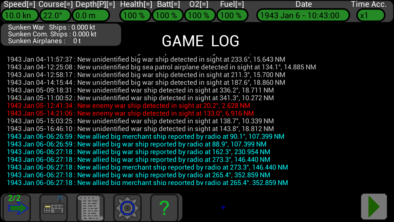
Your score is shown in the top left of the Log screen, it indicates the total tonnage of warships sunken by your submarine, the total tonnage of commercial ships sunken and the total weight of aircrafts destroyed.
The scope of the game is to destroy as much enemies units (RED SYMBOLS) as possible, and in future probably will be possible to use this tonnage to upgrade your submarine (or perhaps to buy other submarines to be used concurrently to perform advance attacks)…
If you destroy an enemy unit (red), its weight is added to your score (Good).
If you destroy a neutral unit (black), its weight is subtracted from your score (Bad).
If you destroy an allied unit (blue), the double of its weight is subtracted from your score (VERY BAD).